Mount Greylock: A History, How-To, And Fun Facts About The Highest Peak In Massachusetts
If you’re going to visit the summit (and you should), this will help you appreciate its magnificence even more.
If you’re going to visit the summit (and you should), this will help you appreciate its magnificence even more.
Berkshire County is famous for its natural beauty and outdoor attractions, and, literally, nothing tops Mount Greylock, Massachusetts’ highest peak.
While there are many stories of how Greylock got its name, there is no question that the 3,491-foot summit is frequently wreathed with grey clouds or mist. The first time this writer ascended to the peak I did not see the 93-foot-tall Veterans War Memorial Tower, made of steely gray Quincy granite, until I literally bumped into it. Gray sky, gray clouds, gray stone — gray was certainly my first impression of the mountain, although visits to the spectacular five-state view on clear days have followed. When you make your ascent — by car, on foot, on a bicycle or horse, or on skis or snowshoes in the winter — you will have your Greylock tale to tell, too.
The 11-mile-long Greylock Massif, with its seven distinct peaks — Saddle Ball Mountain, Mount Fitch, Mount Williams, Mount Prospect, Stony Ledge, Ragged Mountain, and Mount Greylock itself — sits in grand isolation, surrounded by what are now the valleys of the Green and Hoosic Rivers. Towards the end of the last Ice Age, those valleys were filled to the 1,100-foot contour level by the waters of Lake Bascom, named not for Williams College’s alumnus John Bascom but for his daughter, Florence, often referred to as “the first woman geologist in America,” who first posited the lake’s existence.

Photo: Susan Duffy
The summit of Greylock is in the town of Adams, although the only way you can get to the top from that town is on foot. The rest of the massif sprawls over an additional five towns – Cheshire, Lanesborough, New Ashford, North Adams, and Williamstown.
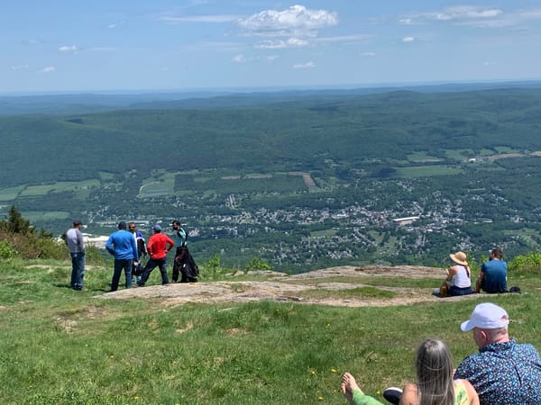
On one of those proverbial clear days you can see sights in Massachusetts, Connecticut, Vermont, New Hampshire, and New York from the summit. Greylock is also a notable regional landmark, visible from high elevations in those five states as well.
How to Approach the Summit
The good news for folks visiting in a car is that the summit of Mount Greylock is remarkably accessible for all ages and abilities. There are two paved roads – Notch Road from North Adams and Rockwell Road from Lanesborough — open to vehicular traffic from dawn to dusk late May to mid-October each year (dates can vary owing to the always unpredictable Berkshire weather). There is no charge to use the roads, but there is a parking fee at the summit and no parking is allowed along the roads themselves. Both roadways are narrow, steep and winding, and so vehicles longer than 22 feet - that includes buses, recreational vehicles, and commercial trucks — are not permitted.
It is unusual to be able to drive up a New England mountain like Greylock, and recent improvements have made the summit, Bascom Lodge, and the base of the War Memorial Tower handicap accessible. Parking at the summit is limited, but folks with a handicap placard can park for free. All of this makes the summit of Mount Greylock the perfect outing for nature lovers who are mobility challenged. Wheelchair and walker users can enjoy the views outdoors as well as the indoor amenities at the Lodge (yes, that includes the restrooms).
If you are approaching the mountain from the south, the fully accessible Visitors’ Center, located 1.5 miles up Rockwell Road from Route 7 in Lanesborough, is well worth a stop. There you can get trail maps and informational brochures, view exhibits, visit the accessible rest rooms, and chat with the staff to gather information to continue your journey. Parking is free for all vehicles.

Photo: Susan Duffy
Mountain Management Since 1895
Throughout the 19th century logging deforested the mountain leading to soil erosion and landslides, while charcoal burning polluted the air and sparked fires. By 1895 an alarmed group of local businessmen formed the Greylock Park Association (GPA) and purchased 400 acres around the summit to prevent further ecological damage. Hoping to attract tourists, they constructed a toll road, charging $10 in today’s money for its use. But business failed to flourish and so the GPA donated the land to the Commonwealth for public use, with the stipulation that the state continue to add to the protected acreage, a process that is still underway. Thus in 1898, Mount Greylock became Massachusetts’ first state reservation, the start of our state park system.
Today, the 12,500-acre Mount Greylock State Reservation is managed and operated by the Massachusetts Department of Conservation and Recreation.
More than a dozen cleared trails, including a segment of the Appalachian Trail, provide access for hikers, bicyclists, equestrians, skiers, and snowshoers. Remember that Greylock is a “serious mountain” and many of the trails are strenuous. Be sure you are ready physically and mentally and well equipped for your outing. Maps are available online, at the Visitors Center, and from various outdoor equipment stores throughout the county. The trails are well maintained, and no motorized vehicles (ATVs, snowmobiles, etc.) are allowed, so people, pets, and horses can traverse them safely.
Thoreau, Melville, and the Mountain
The Bellows Pipe Trail, accessed from Notch Road in North Adams, was first carved out in the late 18th century and is the earliest route white settlers are known to have used. In 1844 Henry David Thoreau followed it and spent a night at the summit, making his bed among boards from the wreckage of an early wooden observation tower. Upon waking the following morning he wrote:
"As the light increased, I discovered around me an ocean of mist, which by chance reached up exactly to the base of the tower, and shut out every vestige of the earth, while I was left floating on this fragment of the wreck of the world, on my carved plank, in cloudland." - from A Week on the Concord and Merrimac Rivers, 1849
Emboldened and inspired by his mountaintop experience, Thoreau commenced his time alone at Walden Pond the following year.
Legend has it that Herman Melville’s view of Greylock, as he sat writing Moby Dick at his Lenox farm, Arrowhead, during the very snowy winter of 1850-1851, reminded him of a great white whale breaching. So enamored was Melville of the mountain that he dedicated his novel 1852 Pierre to its “Most Excellent Purple Majesty.”
Summit Structures Renewed
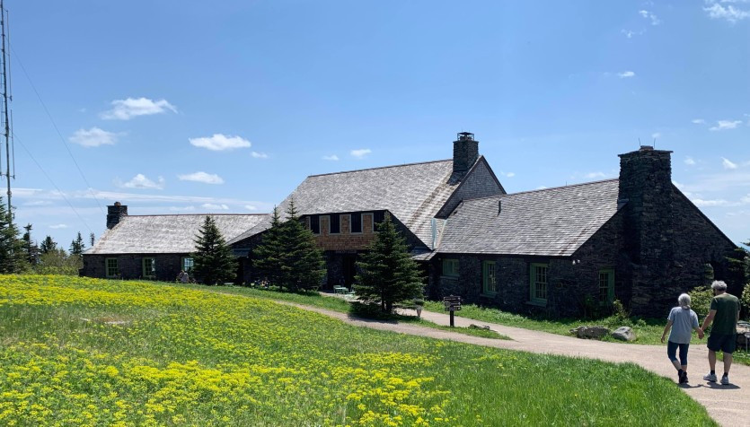
Bascom Lodge. Photo: Mark Rondeau
The Great Depression in the 1930’s brought the most significant man-made changes to the mountain. The Civilian Conservation Corps (CCC), a work relief program that employed millions of young men on environmental projects, constructed Bascom Lodge just below the summit, cleared the two paved roads and numerous trails — opening up dramatic views along the way — and constructed lean-tos for campers.
Capping the peak today is the Veterans’ War Memorial Tower, the Commonwealth’s official war memorial, which is often mistaken for a sadly lost lighthouse because of its brilliant nighttime beacon. Dedicated in 1933 and newly reopened after the latest round of repairs and upgrades, 2022 visitors should find the handicap accessible Memorial Chamber at the base and the not-for-the-faint-of-heart spiral staircase (89 steps!) to that five-state view from the observation deck to be in tip-top shape.
The handsome arts and crafts-style Bascom Lodge, built of Greylock schist and red spruce timbers, first opened in 1937 and is open every season for snacks, gourmet meals, concerts, and talks. Check out the website for menus, entertainment schedules, and information on renting rooms.